


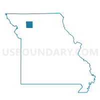
Boyd Voting District, Daviess County, Missouri
About
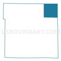
Outline

Summary
| Unique Area Identifier | 607705 |
| Name | Boyd Voting District |
| County | Daviess County |
| State | Missouri |
| Area (square miles) | 35.97 |
| Land Area (square miles) | 35.92 |
| Water Area (square miles) | 0.06 |
| % of Land Area | 99.84 |
| % of Water Area | 0.16 |
| Latitude of the Internal Point | 40.08266740 |
| Longtitude of the Internal Point | -93.83007820 |
Maps

Graphs
Select a template below for downloading or customizing gragh for Boyd Voting District, Daviess County, Missouri


Neighbors
Neighoring Voting District (by Name) Neighboring Voting District on the Map
- Gilman City Voting District, Harrison County, MO
- Jameson Voting District, Daviess County, MO
- Jamesport Voting District, Daviess County, MO
- Madison Voting District, Grundy County, MO
- McClary Voting District, Daviess County, MO
- Taylor Voting District, Grundy County, MO
Top 10 Neighboring County Subdivision (by Population) Neighboring County Subdivision on the Map
- Jamesport township, Daviess County, MO (1,085)
- Madison township, Grundy County, MO (626)
- Sugar Creek township, Harrison County, MO (525)
- Taylor township, Grundy County, MO (179)
- Washington township, Daviess County, MO (141)
- Adams township, Harrison County, MO (135)
- Lincoln township, Daviess County, MO (108)
Top 10 Neighboring Place (by Population) Neighboring Place on the Map
Top 10 Neighboring Unified School District (by Population) Neighboring Unified School District on the Map
- Trenton R-IX School District, MO (7,824)
- Tri-County R-VII School District, MO (2,010)
- Gilman City R-IV School District, MO (785)
- North Daviess R-III School District, MO (772)
Top 10 Neighboring State Legislative District Lower Chamber (by Population) Neighboring State Legislative District Lower Chamber on the Map
Top 10 Neighboring State Legislative District Upper Chamber (by Population) Neighboring State Legislative District Upper Chamber on the Map
Top 10 Neighboring 111th Congressional District (by Population) Neighboring 111th Congressional District on the Map
Top 10 Neighboring Census Tract (by Population) Neighboring Census Tract on the Map
- Census Tract 9501, Harrison County, MO (3,483)
- Census Tract 4701, Daviess County, MO (3,443)
- Census Tract 9602, Grundy County, MO (2,086)